
Loading...
Professional land surveying and topographical mapping services. Comprehensive survey services with advanced methodologies.
Professional surveying services for highway alignment, bathymetric surveys, and comprehensive mapping solutions for infrastructure and development projects.

After map study, engineering or field survey are carried out to finalize the highway alignment. The object of these surveys is to locate the alignment of a road which provides maximum transportation facilities with the minimum cost of construction and maintenance.
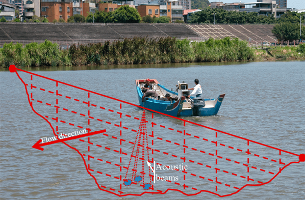
Bathymetric survey, sometimes referred to as a fathometric survey, is a type of hydrographic (water-based) survey that maps the depths and shapes of underwater terrain to illustrate the land that lies below.
Bathymetric surveyors work to obtain an exact representative image of the seabed and identify specific elevations, anomalies, and the presence of any scour around submerged structures.
They also analyze and define the surrounding shorelines, tides, currents, and waves to create a better model of the area features overall.
Optimal road alignment for maximum transportation efficiency and cost-effectiveness.
Detailed bathymetric mapping of underwater terrain and seabed characteristics.
Comprehensive land surveying and topographical mapping services.
Site surveying for construction and infrastructure development projects.
Our survey services aim to provide accurate and reliable data for project planning, design, and construction. We utilize modern surveying equipment and techniques to ensure precision and efficiency in all our surveying operations.
Explore our other survey and mapping services
Comprehensive geological mapping and site characterization.
Comprehensive soil analysis for construction.
Groundwater and subsurface investigation services.
Copyright 2025 GEO Laboratory | Professional Geotechnical Services | All Rights Reserved